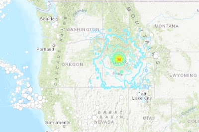
March 31, 2020: Strong earthquake of magnitude 6.5 has been recorded in Idaho at 05:52 pm local time, the United States Geological Survey (USGS) reported.
According to the USGS, the earthquake's epicenter was located 72km W of Challis, Idaho. The earthquake occurred at 10 km depth.
The earthquake was felt by the residents from Nevada to Montana. The tremor was felt as far as 450 km from the epicenter.
The main earthquake was followed by a 4.8 magnitude aftershock around 30 minutes later. There were more than a half-dozen aftershocks in the hours following the main Challis, Idaho earthquake today.
The current Challis, Idaho earthquake is the second-strongest earthquake in the state of Idaho since records began. Also, no earthquakes of magnitude 5+ have occurred within 50 km of this event over the past 50 years.
A 6.9 magnitude earthquake that happened on Oct. 28, 1983 in the Lost River Range at Borah Peak in Central Idaho is the strongest earthquake in this region. The 1983 Borah Peak earthquake claimed lives of two people with aftershocks felt for a year afterwards.
According to our forecast, over the next week there is a 4% chance of one or more aftershocks larger than magnitude 6.5. It is likely there will be smaller earthquakes over the next week, as well, with 4 to magnitude 3 or higher aftershocks. Magnitude 3 and above are large enough to be felt near the epicenter. The number of aftershocks will drop off over time, but a large aftershock can increase the numbers again, temporarily.
Idaho earthquake aftershock forecast (USGS)
According to our forecast, over the next week there is a 4% chance of one or more aftershocks larger than magnitude 6.5. It is likely there will be smaller earthquakes over the next week, as well, with 4 to magnitude 3 or higher aftershocks. Magnitude 3 and above are large enough to be felt near the epicenter. The number of aftershocks will drop off over time, but a large aftershock can increase the numbers again, temporarily.
Challis, Idaho earthquake fault lines
According to the USGS, Challis, Idaho earthquake 2020 occurred as the result of complex strike slip faulting within the shallow crust of the North America plate. This earthquake occurred within the Intermountain Seismic Belt, a prominent zone of recorded seismicity in the Intermountain West, and is within the western part of the Centennial Tectonic Belt, an area of southwest-northeast extension north of the Snake River Plain.
The quake is about 16 km north-northeast of the Sawtooth fault, a 60-km-long normal fault that extends along the eastern base of the Sawtooth Range.
Earthquake Felt Intensity
Light tremor of MMI IV: Meridian, Boise, Nampa, Eagle, Garden City, McCall, Ketchum and Hailey
Weak tremor of MMI II-III: Middleton, New Plymouth, Nampa, Kuna, Caldwell, Parma, Hamilton, Lewiston, Burley, Twin Falls, Buttle, Missoula, Pocatello, Rexburg, Moscow, Pullman, Helena, Bozeman, Elko, Sandpoint, Kalispeli and Spokane
Recommended Post: Recent Natural Disasters in United States 2020
Recommended Post: Recent Natural Disasters in United States 2020
