Disaster Report: Cyclone Giovanna Is Predicted To Grow To A CAT III, With Winds Between 178 To 210km/h. Landfall In Madagascar on February 13. Residents Of Madagascar Need To Prepare For Heavy Rainfall And Flooding
Want To Share!! Let Others Know
Fill this Disaster form or write in comment section below
Follow Disaster Report @ facebook (Disaster Report), twitter (Disaster_Update) and Google +(Disaster report)
Keep This Page Open Or Visit Later To Get Update Report
Recent Natural Disasters List
This page is mainly to track real time updates after "Giovanna" enters Madagascar, if you are the one from Madagascar, kindly report recent activities/plannings/warnings near your area.
Kindly leave your comments below
Check Daily list Of Recent Natural Disasters Around The World With Detail Update Report. Click for Today's Natural Disasters List
Recommended post: Flooding in Mauritius; 8 killed, 82 injured
This is the second part of real time update of Tropical Cyclone "Giovanna". One fatality is reported so far in Mauritius. This page will be giving updates about its impact in Madagascar (click to view status of Giovanna as it was in Mauritius)

Get Latest updates from Disaster Report about this Cyclone@ facebook (Disaster Report), twitter (Disaster_Update) and Google +(Disaster report)
we request anyone (from Madagascar/South Africa) who can help us in preparing detail in-depth report. Kindly if anyone can send updates through Contact form. Real updates are far better. Better if you can keep your detail too. It will be easy to publish your name and location. Thanks for all those comments -Admin
Are you in Madagascar? Have you been been affected by the cyclone? Please let us know your experiences.
UPDATE February23
This is probably the last update on "Giovanna" and "Hilwa". Currently both are in Indian ocean and has weaken to TD/TS. Giovanna which first entered Mauritius caused slight damage there but huge destruction was seen in Madagascar Island. After that Hilwa was predicted to hit again, but tracking route was as forecasted. Thanks to everyone to keep this post alive. Especially locals from Mauritius and Madagascar who reported to Disaster-Report continuously during the incident. If more damage report is obtained, it will be then updated in this page in coming days-Admin
UPDATE February22
 -Now Hilwa seems to be no longer threat to Mauritius (earlier as TS). It was earlier forecast to hit Mauritius if it continues it path from Rodrigues Islands to Mauritius. New tracking image shows it to be moving away from Mauritius heading towards Indian Ocean. It is currently a Tropical storm (till 18:00 UTC today)
-Though Giovanna has already weaken to Tropical Depression (lowest level), it seems again moving towards Toamasina, Madagascar. It means current 1 Minute Maximum Sustained Winds is less than 63 km/hr
UPDATE 02:49 UTC
-From today onwards this page will will track all updates on "Giovanna" and "Hilwa". Currently Hilwa is 100 km NE of Rodrigues. It is just a tropical storm, level below category 1. There can be thunderstorm in the afternoon today
-By mid day today Giovanna will weaken as Tropical Depression (lowest level)
UPDATE February 21
-Tropical Storm "Giovanna" active in Indian Ocean. GDACS still keep RED ALERT for Madagascar. It is currently in Indian Ocean between Mauritius and Madagascar. By mid day today it is forecasted to weaken as just a Tropical Depression. GREEN ALERT IN MADAGASCAR
-Tropical Storm "Hilwa" active in Indian Ocean. It is currently a Tropical storm and by tomorrow it will be weaken to Tropical Depression. GREEN ALERT IN MAURITIUS
UPDATE
Weather Bulletin issued by Mauritius as 16H40 ON MONDAY 20 FEBRUARY 2012 writes
THE TROPICAL DISTURBANCE WHICH WAS EVOLVING TO THE EAST NORTH-EAST OF RODRIGUES HAS INTENSIFIED INTO A MODERATE TROPICAL STORM AND WAS NAMED \'HILWA\'. AT 16H00, \'HILWA\' WAS LOCATED NEAR THE POINT 19.1 DEGREES SOUTH AND 65.5 DEGREES EAST AT ABOUT 200 KM TO THE EAST NORTH EAST OF RODRIGUES. IT IS MOVING IN A GENERAL WESTERLY DIRECTION AT ABOUT 10 KM/H.
FORECAST FOR NEXT 24 HOURS :
-FINE WEATHER AT NIGHT AND TOMORROW MORNING.
-TEMPORARILY CLOUDY TOMORROW AFTERNOON TO THE NORTH-WEST, NORTH AND OVER THE CENTRAL PLATEAU WITH LOCALISED SHOWERS. SUNNY ELSEWHERE.
-WIND LIGHT AND VARIABLE AT NIGHT, SOUTHERLY 15 KM/H TOMORROW.
-SEA MODERATE BECOMING GRADUALLY ROUGH BEYOND THE REEFS WITH
SOUTHERLY SWELLS.
-THE PUBLIC IS ADVISED NOT TO VENTURE IN THE OPEN SEAS AS FROM
TOMORROW.
THE TEMPERATURE WILL BE CLOSE TO THE SEASONAL MEAN AT NIGHT AND
SLIGHTLY ABOVE TOMORROW DURING THE DAY WITH OVER THE CENTRAL
PLATEAU A MINIMUM OF 20 DEGREES CELSIUS AND A MAXIMUM OF ABOUT
28 DEGREES CELSIUS.
ALONG THE COASTS, THE MINIMUM TEMPERATURE WILL VARY BETWEEN
22 AND 25 DEGREES CELSIUS AND THE MAXIMUM BETWEEN 30 AND 33 DEGREES CELSIUS.
HIGH TIDES : TOMORROW 01H14 AND 12H57.
LOW TIDES : 18H53 AND TOMORROW 07H08.
SUNRISE : 06H04.
SUNSET : 18H44.
THE ATMOSPHERIC PRESSURE AT 16H00: 1008 HECTOPASCALS.
UPDATE
-17 children missing including 10 in the city of Antananarivo, especially in the affected areas as Andavamamba, Ampefiloha-Ambodirano and Andohatapenaka
Following Newsmada, "Les enfants issus des familles hébergées dans les tentes courent actuellement beaucoup de risques surtout en cette période de cataclysmes naturels dont le cyclone et les inondations. « La plupart des enfants ne se sentent plus en sécurité face à la promiscuité dans les tentes qui abritent près de 40 personnes. Ils font face à plusieurs contraintes et parfois l’absence des parents, devant subvenir à leurs besoins quotidiens, favorise les tentatives de viol, voire les actes malsains entre les enfants », a expliqué le premier responsable du Syndicat professionnel des diplômés en travail social (SPDTS), Jeannoda Norotiana Randimbiarison. Viennent ensuite la disparition des enfants qui concerne la tranche d’âge variant entre 10 et 18 ans ainsi que l’abandon ou l’égarement des enfants en bas âge"
UPDATE February 20
-25 dead, 81 injured and more than 256,000 victims
-Over 100 schools, hospitals, churches and offices damaged
UPDATE February 19
-Death toll has risen to 17
-UNICEF warned for potential outbreaks of water-borne diseases
-About 2,000 people have been displaced by Cyclone Giovanna
-UN Humanitarian Affairs office (OCHA) says the tropical storm also affected agricultural production, damaging banana, litchi and sugar cane crops.
UPDATE February 18
-It is currently moving away from Madagascar (Ambovombe) towards Indian Ocean
UPDATE 09:40 UTC
UPDATE February 17
-Mozambique’s National Meteorological Institute (INAM) urged people of southern provinces of Gaza and Inhambane to be on HIGH ALERT
-Cyclone Giovanna is about to approach the southern province.
ALERT for Inhambane: Districts of Jangamo, Maxixe, Zavala, Inharrime, Panda, Homoine, Morrumbene, Massinga, Funhalouro and Vilankulo and the provincial capital, Inhambane city
-The cyclone has been currently traveling at a speed of 150 kilometers per hour
-Following Mozambique’s National Emergency Operational Center (CENOE), disaster response team are READY (active)
UPDATE
-About 40 schools damaged
UPDATE
-National Office of Risk Management and Disaster (BNGRC) send seven tonnes of white rice and two tonnes of pulses, 45 boxes of soap, 5 boxes of candles and offered 200,000 families affected by cyclone-United States provided Malagasy government with emergency assistance of 50,000 dollars for disaster
-France: one million euros for the rehabilitation and construction of roads, tracks and dams
UPDATE February 16
-Following Météo France, a new low pressure system(depression) in the area has formed Located at 2950 kilometers east coast of Reunion currently. The tropical depression called "Hilwa" is moving at 15km/h towards the Southwest
UPDATE
 |
| Visible image of Cyclone Giovanna in the Mozambique Channel at 10:45 UTC (5:45 a.m. EST) on Feb. 15, 2012; NASA |
-65 injured and 11,000 homeless
UPDATE
Now, the question is Where is Cyclone Giovanna right now? Has it passed Madagascar? Aside is NASA image taken at 10:45 UTC (5:45 a.m. EST) on Feb. 15, 2012 which shows that Cyclone Giovanna has entered the Mozambique Channel.
UPDATE 16:32 UTC
-Death toll at 10 with more than 15 missing
-Houses made of bamboo and wood washed away in floods in Madagascar
-More than 20 hospitalized
-ShelterBox Operations will arrive at the island on 17 February to assess the need for emergency aid which will work in coordination with National Disaster Relief Agency
-Now Mozambique, on the south-eastern coast of Africa on HIGH ALERT
UPDATE
-Death toll has risen to 10
UPDATE 10:32 UTC
-Death toll has risen to five
UPDATE
-The road from Anivorano to Brickaville is blocked
-80% of electricity poles are down in Brickaville
UPDATE February 15
- At least 3 people are reported to be killed by TC Giovanna in Madagascar with widespread damage. Damage report yet to come
-Several part including capital Antananarivo, are still without water, electricity or telephone services
-UNICEF has started proving emergency supplies to assist 100,000 people in Madagascar. The emergency supplies include mosquito nets, water purification devices and school kits
-By Saturday, Giovanna will enter Mozambique where winds of 65 knots (120 km an hour) are forecast, with gusts of 80 knots
UPDATE 17:54 UTC
Damage Reports
-Two people reported to be dead so far
-7 out of 10 houses have been destroyed in the district of Vatomandry
-Some bridges and roads especially between the district of Toamasina and the Capital Antananarivo
-Two helicopters will be surveying the affected areas
UPDATE 15:56 UTC
-Brickaville and Vatomandry, located 200km from the capital Antananarivo, worse affected by TC Giovanna destroying 75% to 95%. Actual detail report will be flashed as team will reach the spot probably by tomorrow
-Most government buildings have been completely destroyed
-Madagascar cyclone is expected to leave by late today
-But according to Météo France, it could return to the island in the coming days.
UPDATE 15:28 UTC
-Now the question is "Where is Giovanna situated right now in Madagascar?" Currently at the time of updating, Cyclone Giovanna is 91km ENE of Belo-sur-Tsiribihina, near Itondy.
The cyclone is now passing the southern end of Tsingy de Bemaraha National Park and is expected to reach the Mozambique Channel just north of Belo-sur-Tsiribihina around 19:00 local time
-Now there is report of another storm currently in Indian Ocean approximately 1000 miles east-southeast of Diego Garcia which could strike Madagascar next week
UPDATE
-One person is reported to be killed in the inland sugar-producing town of Brickaville after an electricity pole fell on her
UPDATE 04:40 UTC
-The imminent danger has been declared for regions Analanjirofo Atsinanana, Alaotra Mangoro Betsiboka Menabe Atsimo-Andrefana, Amoron'i Mania, Matsiatra-Ambony and all regions of the former province of Antananarivo
-About 10,000 households experienced power cuts
-The town of Tampon worse affected
-206mm of rainfall in volcano,139mm in Cilaos, 113mm to the Plain of Kaffirs. It has given somewhat relief to the farmers. The area was experiencing drought from several months. Dams are also filled
UPDATE February 14, 04:14 UTC
-Madagascar (Giovanna) is still under RED ALERT
-However, by 2/14/2012 12:00:00 AM, it is lowered to Category 2 with Maximum sustained wind speed 175 km/hr
- 650 thousand people will be affected due to this TC in some hours
-The cyclone made landfall at about two o'clock in the morning, between the district of Toamasina and Vatomandry
-Schools and offices closed in eastern port city of Tamatave
UPDATE
-Giovanna crossed the east coast of Madagascar overnight causing heavy rainfall
-Power cut in Antananarivo
-Strong wind and heavy rainfall in Tana. No cell contact in West Coastal area
-Internet connection interrupted
-Air Madagascar cancelled all flights leaving from Antananarivo
UPDATE
-Tropical cyclone Giovanna arrived Madagascar at about 20:00 GMT on 13 February.
UPDATE
-One of the visitor has just mentioned though Contact form from Antananarivo, Madagascar that Warning is in effect for Analanjirofo Atsinanana, Alaotra Mangoro-and-Vatovavy Fitovinany and the District of Antalaha, Befandriana North , Mandritsara Vondrozo, Vohipeno and Farafangana region of Madagascar"
-Sf Nathani reports "Disaster report" from Antananarivo, " it 10.45pm 13th feb'12. wind blowing and its starts raining"
UPDATE
-GDACS has kept Red Tropical Cyclone Alert In Madagascar For GIOVANNA-12
-940 thousand people will be affected by this cyclone in Madagascar-HIGH ALERT for Antananarivo and Toamasina region of Madagascar
-Worse effect will be seen in Atsinanana and Vatomandry airport
-According to the weather service, "heavy rain accompanied by gale force winds are expected throughout the province of Toamasina, the Regions and Vatovavy-Fitovinany Sofia, and in-Atsimo Atsinanana from Monday after- noon"
UPDATE 15:58 UTC
- Tropical cyclone Giovanna is about to strike Madagascar. It is a powerful Category 4 storm with 145 mph winds. It is forecast to then cross the island and pass by the capital Antananarivo as a category three tropical cyclone and then enter the Mozambique Channel as a category one tropical cyclone by Wednesday 15 February
-According to the Saffir-Simpson damage scale the potential property damage and flooding from a storm of Giovanna's strength (category 3)at landfall includes:
- Storm surge generally 2.7-3.7 metres (9-12 feet) above normal.
- Some structural damage to small residences and utility buildings with a minor amount of curtain wall failures.
- Damage to shrubbery and trees with foliage blown off trees and large trees blown down.
- Mobile homes and poorly constructed signs are destroyed.
- Low-lying escape routes are cut by rising water 3-5 hours before arrival of the center of the storm.
- Flooding near the coast destroys smaller structures with larger structures damaged by battering from floating debris.
- Terrain continuously lower than 1.5 meters (5 feet) above mean sea level may be flooded inland 13 km (8 miles) or more.
- Evacuation of low-lying residences within several blocks of the shoreline may be required.
UPDATE
Getting lot of mails and comments, One of the visitor has just mentioned though Contact form the current scenario of Madagascar,"We people from the coastal region are warned for severe effect. Till now the weather is calm"
we request anyone (from Madagascar/South Africa) who can help us in preparing detail in-depth report. Kindly if anyone can send updates through Contact form. Real updates are far better. Better if you can keep your detail too. It will be easy to publish your name and location. Thanks for all those comments -Admin
UPDATE 02/13
-Hurricane Giovanna is going to make landfall in Madagascar Island region in some hours. People in Madagascar are ready to batter this situation which may be worst in Madagascar history as forecaster says. Earlier cyclone Geralda passed from same region causing heavy destruction. This time people are themselves in ALERT STATUS (hope no major damage). Personally advice that residents of central and eastern portions of Madasgascar should prepare and better evacuate the coastal areas
-Unconfirmed report from Madagascar says, People in Coastal region are little panicked as the Hurricane is approaching near. Some have even left their home
-After four days, Giovanna is forecasted to arrive at the southern Mozambican coastline i.e approximately Wednesday Feb 17, 2012
UPDATE 02/12
Giovanna will make landfall near Toamasina and continue westward across Madagascar. If it strikes Madagascar as a category 4 storm (as forecasted), it will cause heavy destruction. Following similar path, Cyclone Geralda caused catastrophic damage in Madagascar in late January 1994. Cyclone Geralda made landfall near Toamasina, Madagascar after weakening into a Category 3 storm on February 2-3. The time and location are about to same.
 |
| Storm path of "Geralda" (1994). The path and location (+ time) are about to same for both "Giovanna" and "Geralda". When "Geralda" made a landfall just south of Toamasina, it destroyed 80% of the city's seaport. Current "Giovanna" is too passing from same region |
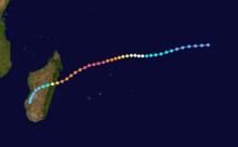
| Path of Cyclone "Giovanna". It is heading towards Madagascar |
It is currently moving towards land (Antananarivo) with significant wave height 26 feet. It will make landfall (flooding + heavy rainfall) on February 13. In two days (Feb. 13 + Feb. 14) the impact can be great as forecasters says. So people in Madagascar should prepare for it. It will enter Madagascar late night (Feb. 13) and impacts will be seen on February 14 where it will last for whole day and will leave Madagascar late 14th February
After February 14, the cyclone impact will be less, just as a "Tropical storm" which will then passes to Mozambique. Mozambique is already hit by Tropical cyclones "Dando" and "Funso" which caused heavy rainfall and flooding taking lives of 40
It's effect can be seen in Marovoay, Madirovalo, Toamasina, Ambatondrazaka, Saka, Antananarivo, Antanifosty, Antsirabe, Fianarantsoa, Manakara, Farafagana, Benzaha, Toliara region. It will cause effect on almost all region but mainly in Central Part.
Place Overview
The Republic of Madagascar is an island country located in the Indian Ocean off the southeastern coast of Africa. The nation comprises the island of Madagascar (the fourth-largest island in the world), as well as numerous smaller peripheral islands. In the Malagasy language, the island of Madagascar is called Madagasikara and its people are referred to as Malagasy.At 592,800 square kilometres, Madagascar is the world's 47th-largest country and the fourth-largest island
Tags: cyclone giovanna madagascar 2012, disaster report cyclone giovanna, hurricane in madagascar, giovanna toamasina madagascar, actual position of giovanna cyclone, Giovanna cyclone, Cyclone Giovanna, cyclone prediction, flooding in Madagascar, cyclone giovanna bulletin, Giovanna image, Madagascar, Madagascar hurricane, NASA image Giovanna, natural disasters, recent disasters, storm, Tropical Cyclone, GIOVANNA, giovanna trajectory Madagascar, cyclone in Madagascar 14 february 2012, Tropical storm, expected track giovanna storm, jtwc + giovanna tropical cyclone, giovanna trajectory, cyclone in madagascar latest updater, active storms giovanna's. indian ocean, Madagasikara cyclone, Madagascar hurricane giovanna, cyclone giovanna news "south africa", Cyclone Giovanna Latest Update, Cyclone Tropical "Giovanna", cyclone in Madagascar 13 feb 2012, news mada, cyclone alert Madagascars, forecast tropical cyclone giovanna, cyclone giovanna news?, landfall prediction for cyclone Giovanna, L'ouragan "Jeanne", cyclone giovanna madagascar feb 13, giovanna madagascar, cyclone giovanna madagascar current position
we in Madagascar are alerted every time..every where the cyclone news has been spreading like wild fire..hope it will be quiet..oh god..less than 2 days..
ReplyDeletestill remember, the Cyclone Gerald... it was deadly...my brother living in Toamasina region was too effected... hope this will not be like that :(((
ReplyDeleteHow's it going over in Mauritus? My brother is in a hotel there.
ReplyDeleteVery calm, almost like no cyclone in Mauritius. I am near the centre of the island, where the effects are supposed to be the most felt, because of the higher grounds. Really no reason to worry. Not even a tree is down. Electricity, phone, water supply and internet connection all intact(as u can see)
DeleteHow´s it going over in St Louis? My son is there....
ReplyDeleteis it category 3 cyclone??..surprised>> NO ANY IMPACT..fine in St louis..
DeleteHello everyone, as mentioned this page is created to track real live updates when the storm leaves Mauritius!! Regarding the latest situation of Mauritius, recommended to visit the first post @
ReplyDeletehttp://disaster-report.blogspot.com/2012/02/update-tropical-cyclone-giovanna-active.html
If you are from Madagascar/south Africa side, you can add your experience or report live updates during surge period in this very post and kindly add your location and name if you want to publish your name in this post.
Thanks
hello admin..currently from Madagascar..will update you and send email when it will reach Madagascar after two days...
Deleteeffects r being felt. Big cyclone. If not weakened zer gonna b great destruction in Madagascar
DeleteTROPICAL CYCLONE (TC) 12S (GIOVANNA), LOCATED APPROXIMATELY 200 NM
ReplyDeleteNORTH-NORTHEAST OF LA REUNION, HAD TRACKED WESTWARD AT 10
KNOTS OVER THE PAST SIX HOURS. ANIMATED MULTISPECTRAL SATELLITE
IMAGERY SHOWS THAT TC 12S IS STRUGGLING TO MAINTAIN A CLOUD-FREE
EYE. A 121108Z AMSU-B IMAGE INDICATES AN APPROXIMATELY 35 NM WIDE
EYE. COMPARISON OF THIS AMSU-B IMAGE TO AMSU-B IMAGES IN THE PAST 6-
12 HOURS REVEALS A WEAKENING IN THE DEEP CENTRAL CONVECTION
SURROUNDING THE LOW-LEVEL CIRCULATION CENTER (LLCC). THE CURRENT
POSITION IS BASED ON AGREEABLE PGTW, KNES, FMEE, AND FIMP CENTER
FIXES ALONG WITH THE AMSU-B IMAGE WITH HIGH CONFIDENCE. THE CURRENT
INTENSITY IS BASED ON DVORAK ESTIMATES OF 90-102 KNOTS FROM THESE
REPORTING AGENCIES. UPPER-LEVEL ANALYSIS CONTINUES TO SHOW A SELF-
INDUCED MESO-ANTICYCLONE OVER THE LLCC WHICH IS PRODUCING EXCELLENT
DIVERGENCE ALOFT AND WEAK VERTICAL WIND SHEAR (VWS). ANIMATED WATER
VAPOR IMAGERY ALSO CONTINUES TO SHOW EXCELLENT RADIAL OUTFLOW. TC
GIOVANNA'S TRACK SPEED HAD ACCELERATED OVER THE PAST SIX HOURS AS A
DEEP-LAYERED SUBTROPICAL RIDGE (STR) BUILDS IN FROM THE SOUTH. THE
SYSTEM WILL TRACK WESTWARDS ALONG THE NORTHERN PERIPHERY OF THIS STR
DURING THE NEXT TWO DAYS. DURING THIS TIME TC 12S SHOULD SLIGHTLY
INTENSIFY AS IT MAKES LANDFALL OVER CENTRAL MADAGASCAR JUST AFTER
TAU 36. DURING TAU 48 THE LLCC WILL WEAKEN SIGNIFICANTLY DUE TO THE
FRICTIONAL FORCES OF TOPOGRAPHIC INTERACTION. BY TAU 72 THE SYSTEM
SHOULD EMERGE OVER THE WARM WATERS OF THE MOZAMBIQUE CHANNEL AND
TRACK SOUTHWESTWARDS ALONG THE WESTERN PERIPHERY OF THE STR. BY TAU
96, THE LLCC MAY HEAD TOWARDS A SLIGHT COL REGION IN BETWEEN THE STR
TO THE EAST AND A BUILDING RIDGE OVER SOUTHERN AFRICA. BY TAU 120
THE NEW STEERING INFLUENCE OF THE STR OVER SOUTHERN AFRICA MAY
DEFLECT TC 12S ON A MORE WEST-NORTHWESTWARDS TRACK INTO SOUTHERN
MOZAMBIQUE WHERE THE SYSTEM WILL BEGIN TO DISSIPATE OVERLAND. DURING
ITS TRANSIT OVER THE MOZAMBIQUE CHANNEL THE SYSTEM SHOULD ONLY
SLIGHTLY RE-INTENSIFY DUE TO THE UNFAVORABLE INFLUENCES OF VWS AND
LIMITED TIME OVER WATER. NUMERICAL MODEL GUIDANCE IS IN TIGHT
AGREEMENT UNTIL THE LLCC TRACKS OVER MADAGASCAR AND EMERGES OVER THE
CHANNEL AND IS SPLIT INTO TWO MAIN GROUPINGS. THE ECMWF, NOGAPS, AND
GFS LIE RIGHT OF CONSENSUS AND THE GFDN AND EGRR LIE TO THE LEFT.
THIS FORECAST FAVORS THE FIRST GROUPING TO THE RIGHT OF CONSENSUS
BASED ON MORE MEMBERS AND PAST MODEL PERFORMANCE. MAXIMUM
SIGNIFICANT WAVE HEIGHT AT 121200Z IS 26 FEET. NEXT WARNINGS AT
130300Z AND 131500Z.//
NNNN
waiting Giovanna in Madagascar, will be giving you update from Madagascar...
ReplyDeletehello admin reporting from Antananarivo, Madagascar..............
ReplyDeleteOvercast with rain. High of 25°C. Winds from the North at 20-25 km/h. Chance of rain 90% with rainfall amounts near 33.8 mm possible. Tropical Cyclone Giovanna: Estimated distance to storm center 200 km. Max sustained winds 62 km/h with stronger gusts possible.
little wind, some rain, swell, Giovanna has passed in a relatively unobtrusive to 23 pm Sunday, 320 km north of Reunion
ReplyDeletelatest update
ReplyDeleteTROPICAL CYCLONE (TC) 12S (GIOVANNA), LOCATED APPROXIMATELY 95 NM
EAST OF ANTANANARIVO, MADAGASCAR, HAS TRACKED WESTWARD AT 15 KNOTS
OVER THE PAST SIX HOURS. ANIMATED INFRARED (IR) SATELLITE IMAGERY
SHOWS TC 12S HAS MOVED OVER LAND AT 132200Z. THE PROMINENT EYE
FEATURE HAS BEEN LOST AS THE SYSTEM HAS TRACKED OVER MADAGASCAR FOR
THE PAST TWO HOURS. THE CURRENT POSITION IS BASED ON FIXES FROM PGTW
AND KNES. THE CURRENT INTENSITY IS BASED PREDOMINANTLY ON THE
STRUCTURAL APPEARANCE AND OBSERVED DEGRADATION OF THE SYSTEM FROM
THE PREVIOUS DVORAK INTENSITY FIXES BY JTWC AND KNES. TC 12S IS
TRACKING ALONG THE NORTHERN PERIPHERY OF A SUBTROPICAL RIDGE (STR)
AND IS FORECAST TO SHIFT TO A SOUTHWESTWARD TRACK, NEAR TAU 24, AS A
MID-LATITUDE TROUGH WEAKENS THE WESTERN HALF OF THE STR. THE
TRANSITORY TROUGH WILL MOVE TO THE EAST ALLOWING A STR OVER SOUTHERN
AFRICA TO BUILD EASTWARD, BECOMING THE DOMINANT STEERING INFLUENCE
BEYOND TAU 48. THE STR WILL CAUSE TC 12S TO TRACK WESTWARD INTO
MOZAMBIQUE. AS TC 12S CROSSES OVER MADAGASCAR, THE INTENSITY IS
EXPECTED TO RAPIDLY WEAKEN THROUGH TAU 24 DUE TO FRICTIONAL LAND
EFFECTS. AFTER RE-EMERGING IN THE MOZAMBIQUE CHANNEL, TC 12S WILL
BEGIN TO RECONSOLIDATE AND START STRENGTHENING AS THE OVERALL
ENVIRONMENT REMAINS FAVORABLE WITH SEA SURFACE TEMPERATURES NEAR 29
DEGREES CELSIUS, LOW VERTICAL WIND SHEAR, AND UPPER LEVEL OUTFLOW
SUPPORTING THE LOW LEVEL DEVELOPMENT. BETWEEN TAU 96 AND TAU 120 TC
12S IS EXPECTED TO MAKE LANDFALL IN MOZAMBIQUE, AND BEGIN
DISSIPATING. MODEL GUIDANCE IS IN VERY GOOD AGREEMENT THROUGH TAU
48, HOWEVER SPREADS CONSIDERABLY BEYOND. THIS FORECAST IS BASED ON
CONSENSUS THROUGH TAU 48, BUT PREFERS THE NGPS AND GFS SOLUTIONS
BEYOND TAU 48. NEXT WARNINGS AT 141500Z AND 150300Z.//
Can anyone tell, Where is Giovanna situated right now???
ReplyDeletePassed Madagascar....with severe destruction.......heading Mozambique
DeleteWill Cyclone Giovanna hit Madagascar for a second time? The latest predicted trajectory suggests it may turn back towards southwest Madagascar on Saturday.
ReplyDeleteanother storm currently in Indian Ocean approximately 1000 miles east-southeast of Diego Garcia which could strike Madagascar next week
Delete