Disaster Report: Currently Two-E is just a tropical depression but it is expected to
become a tropical storm late today (Tuesday) and a hurricane on
Wednesday.
Want To Share!! Let Others Know
Report through contact form or write in comment section below
Follow Disaster Report @ facebook (Natural Disasters list), twitter (Disaster_Update) and Google +(Disaster Report)
Keep This Page Open Or Visit Later To Get Update Report
Delivering Continuous exclusive updates on Twitter, Click here
Refresh for more updates
Update 16:35 UTC
-The Hurricane Bud has downgraded to a tropical depression. NO LONGER DANGER TO THE COAST OF JALISCO.
Update 16:26 UTC
-Beaches of Melaque filled with plant debris caused by hurricane bud (as seen below, image source noticiasdelgobiernodejalisco)
-No any damage by hurricane bud in Metro Manila.

Update 2012/05/26; 01:15 UTC
-The government of Mexico has changed the Hurricane Warning for the coast of Mexico from Manzanillo to Cabo Corrientes to a Tropical Storm Warning.
-The government of Mexico has discontinued the Hurricane Watch and the Tropical Storm Warning for the coast of Mexico east of Manzanillo to Punta San Telmo.
Update
-RED ALERT for for the South Coast of Jalisco from 19:00 hrs.
-The Hurricane BUD degrades to a Tropical Storm.
Update
-69 shelters made in 11 municipalities in North and South Coastal region of the state.
-In the South Coast Region, there a total of 45 temporary shelters. Four shelters are operating in the municipality of Cihuatlan where around 110 people are taking shelter. Similarly there are two shelters operating in the municipality of La Huerta. There are 80 people in the shelter.
Cihuatlán- 10 shelters
Cuautitlán Garcia Barragan- 10
La Huerta- 10
Autlan de Navarro- 8
Villa Purification- 4
Casimiro Castillo- 3
Puerto Vallarta- 9 spaces
Tomatlan- 9
Cape Corrientes- 6
Update
-Separate heavy storms reported in Cuba and the Bahamas. According to Cuba's civil defense agency, a French citizen, Alain Manaud, and Silvestre Fortun Alvarez of Cuba were missing after trying to cross rain-swollen rivers.

Update 20:37 UTC
Bud is predicted to make downfall approx. 15 Kms south of Cruz de Loreto in Tomatlan.
Update 19:46 UTC
BUD moves towards the coasts of Jalisco.
Update 18:50 UTC
-The Hurricane Bud is degraded to category 1.
-Hurricane Bud is currently located 85kms south / southwest of La Fortuna, Jalisco and 120kms west of Manzanillo moving north at 11km / h.
-Still ORANGE ALERT continues.
Update

Update 17:20 UTC
Huracan Bud Vientos Máximos sostenidos de 160km/h y Rachas de 200km/h Se mantiene en Categoria 2.
According to the Saffir-Simpson damage scale the potential property damage and flooding from a storm ofBud'sstrength (category 2)at landfall includes:
-Storm surge generally 1.8-2.4 metres (6-8 feet) above normal.
-Some roofing material, door, and window damage of buildings.
-Considerable damage to shrubbery and trees with some trees blown down.
-Considerable damage to mobile homes, poorly constructed signs, and piers.
-Coastal and low-lying escape routes flood 2-4 hours before arrival of the storm center.
-Small craft in unprotected anchorages break moorings.
Update 17:07 UTC
NASA's Tropical Rainfall Measuring Mission (TRMM) satellite passed above Hurricane Bud early this morning, May 25 at 0429 UTC (12:49 a.m. EDT/U.S.). A large area of moderate to heavy rainfall with rates of over 30mm/hr (~1.2 inches) was revealed in Bud by TRMM's Microwave Imager (TMI) instrument. The rainfall analysis was overlaid on an enhanced infrared image derived from TRMM's Visible and InfraRed Scanner (VIRS) and created at NASA's Goddard Space Flight Center in Greenbelt, Md. Bud's past and predicted locations are shown overlaid in white. Heavy rainfall from hurricane Bud's slow movement may result in severe flooding and dangerous landslides as it moves over Mexico's rugged coastal terrain.
Update 16:48 UTC
Hurricane warning extended to the coast of Nayarit. Nayarit is bordered by the states of Sinaloa to the northwest, Durango to the north, Zacatecas to the northeast and Jalisco to the south.
Update 16:04 UTC
Hurricane bud is located 150 km west-southwest of Manzanillo, Colima and 225 km south of Cabo Corrientes, Jalisco.
Update 15:49 UTC
-ORANGE ALERT for Jalisco regarding the hurricane bud. It is better the local people stay in shelter until the danger passes. Jalisco is located in Western Mexico and its capital city is Guadalajara. In the highlands of the Sierra de Manantlán, Cacola, Cuale and Mascota near the coastal plains there is the most rainfall reaching 1600mm per year. In the highlands, the average temperature is less than 18C.
Jalisco está en ALERTA NARANJA a causa de huracán BUD manténgase a resguardo hasta que pase el peligro NO EXPONGA SU VIDA y a su familia.
Update 15:45 UTC
-People living in the coastal municipalities of Jalisco are urged to take shelters to nearby evacuation centers. This is the immediate notice to people of coastal region.
Update 15:12 UTC
-Worsening weather conditions in South Coast of Jalisco, intermittent heavy rain and gusts of wind reported. Better avoid crossing rivers or streams. It can be fatal.
Update 15:05 UTC
-Drain outlet being opened at Lake San Patricio. To prevent the outflow of lake, the measure is taken. Lake is currently at full capacity.
Update 14:46 UTC
-It is raining in Manzanillo. Temperature is around 30 degree Celsius. Manzanillo, located on the Pacific Ocean, contains Mexico's busiest port. It is one of the country's most important tourist resorts. Hurricane Bud is currently located 170 km SW of Manzanillo.
Current Weather Data (For Manzanillo)
Pressure- 1007.7 hPa
Visibility- 16.1 kilometers
Clouds- Mostly Cloudy
Humidity- 92%
Rainfall- 5 mm
Update 14:12 UTC
-Hurricane Bud is expected to reach the coast of Mexico tonight.
-Hurricane bud is currently located 170 km SW of Manzanillo and 270 km S of Cabo Corrientes, Mexico.
Update 10:25 UTC
-Bud weakens slightly but is still expected to reach the coast of Mexico as a hurricane on Friday.
-Bud is located 210 km SW of Manzanillo and 310 km S of Cabo Corrientes, Mexico.
-Schools in 11 communities in Jalisco already closed.
-Below is the scenario of beach in Puerto Vallarta, Mexico – where Hurricane Bud is expected to hit. Swimming is temporarily banned as a precaution.

Update 5:50 UTC
-Bud is currently heading for the coast of southwestern Mexico.
-It is located 240 km SW of Manzanillo Mexico and 335 km S of Cabo Corrientes Mexico.
Update 04:40 UTC
-School in low-lying communities cancelled. Emergency shelters being prepared.
Update 2012/05/25; 03:21 UTC
-Bud is located 270 km SW of Manzanillo Mexico.
-A Hurricane Warning is in effect for the coast of Mexico from Manzanillo northwestward to Cabo Corrientes and the coast of Mexico from Punta San Telmo westward to east of Manzanillo. A Tropical Storm Warning is in effect for the coast of Mexico from Punta San Telmo westward to east of Manzanillo and the coast of Mexico north of Cabo Corrientes to San Blas.
-Bud is a category three hurricane on the Saffir-Simpson wind scale.
-Bud is expected to reach the coast of Mexico as a hurricane by friday afternoon.
-Bud is expected to produce total rain accumulations of 5 to 8 inches along the southwestern coast of Mexico in the states of michoacan, Colima, Jalisco and southern nayarit with possible isolated maximum amounts of 12 inches. These rainfall amounts could produce life-threatening flash floods and mudslides.
-A dangerous storm surge is expected to produce significant coastal flooding near and to the east of where the center makes landfall (video)
Update 17:40 UTC
-Bud is now located 405 km SW of Manzanillo Mexico.
-A Tropical Storm Warning is in effect for the coast of Mexico from Punta San Telmo westward to Cabo
Corrientes and a Hurricane Watch is in effect for the coast of Mexico from Punta San Telmo westward to Cabo Corrientes.
-The coast where Bud is headed towards is very mountainous, and flash floods and dangerous mudslides will be a concern there. The region was not under drought conditions as of the end of April, but a number of wildfires are currently burning in the area, so Bud's rains may also do some good, by extinguishing these fires.
Update

This image provided by NASA taken at 2 a.m. EDT Thursday May 24, 2012 shows Hurricane Bud.
Update 10:02 UTC
-Green Alert for Michoacan and Colima and Blue Alert for Guerrero, Jalisco and Oaxaca. The alert level indicates moderate danger to the Central Pacific coastal region.
Update 09:21 UTC
-The storm probably will not impact the coast of Jalisco (following current tracking map and data) but tomorrow there can be shed rainfall in several areas of the state.
-According to Civil Defence, the alarm light is in blue phase (minimal risk).
Update 09:12 UTC
-Bud is now located 560 km SW of Manzanillo Mexico.
-The government of Mexico has issued a Tropical Storm Warning along the Pacific coast from punto telmo westward to Cabo Corrientes. A Hurricane Watch has also been issued from punto telmo westward to
Cabo Corrientes. Note that Tropical Storm Warning means that tropical storm conditions are
expected somewhere within the warning area within 36 hours. A Hurricane Watch means that hurricane conditions are possible within the watch area.-Bud is expected to produce total rain accumulations of 4 to 6 inches along the southwest coast of Mexico from the states of michoaca, Colima, Jalisco and southern nayarit with possible isolated maximum amounts of 10 inches.
These rainfall amounts could produce life-threatening flash floods and mudslides.
 BUD HAS BEEN MOVING A LITTLE EAST OF DUE NORTH OVERNIGHT. THE HURRICANE IS FORECAST TO TURN NORTHEASTWARD TODAY AS A TROUGH DEEPENS ALONG THE WEST COAST OF THE UNITED STATES. AS BUD APPROACHES THE COAST OF SOUTHWEST MEXICO. THE CYCLONE IS EXPECTED TO SLOW DOWN AS THE TROUGH LIFTS OUT.
As seen in the image aside, bud has developed to a Cat 2, hurricane, for which 1 Minute Maximum Sustained Winds is between 154-177. It is dangerous but the center is far (Cat 2 impact within circle). As it moves further, its seems to be weakening and finally changing its route too.
Update 2012/05/24
-As of 800 PM PDT (0300 UTC), tropical storm bud is located 655 km SW of Manzanillo Mexico.
-The government of Mexico has issued a tropical storm watch along the Pacific coast from Punta San Telmo to la Fortuna.
-The center of Bud is forecast to approach the southwestern coast of Mexico by late Friday.
OVER WARM WATERS AND IN A LIGHT-SHEAR AND RELATIVELY MOIST
ENVIRONMENT...BUD SHOULD REACH HURRICANE STRENGTH SHORTLY. BEYOND
24 HOURS...PROGRESSIVELY COOLER WATERS...A DRIER AND MORE STABLE
ENVIRONMENT...AND SOME MARGINAL INCREASE IN SOUTHERLY SHEAR WILL
LIKELY INDUCE WEAKENING. THE PROXIMITY OF THE TRACK TO SOUTHWESTERN
MEXICO IN 48-72 HOURS SUGGESTS THE POTENTIAL FOR LAND INTERACTION
AND AN EVEN FASTER WEAKENING THAN PREDICTED. EITHER THE LESS
FAVORABLE ENVIRONMENT OR INTERACTION WITH THE MEXICAN COAST SHOULD
CONTRIBUTE TO WEAKENING TO REMNANT LOW STATUS LATER IN THE FORECAST
PERIOD. THE OFFICIAL NHC INTENSITY IS SIMILAR TO BUT SLIGHTLY HIGHER
THAN THE PREVIOUS ONE AND CLOSEST TO THE FSSE MODEL OUTPUT
Update 17:27 UTC
Forecast for May 24

-The image above is the tracking route for Bud for May 24 (early morning and mid day). As earlier Bud was expected to enter Mexico from manzanillo, now from this image it shows diversion in its path. But it is just a expected tracking route for tomorrow. If the recent route is considered for explanation, storm will have certain impacts in Mexico in next 69 hours only. It means by May 26.
-For May 25, there is 50% chance of precipitation in Manzanillo, Mexico.
-Today it is forecast to be Warmer than yesterday.
Update 2012/05/23
At 800 am PDT (1500 UTC), the center of Tropical Storm Bud was located near latitude 13.4 north longitude 107.6 west. Bud is moving toward the northwest near 9 mph (15 km/h). A turn toward the north with a decrease in forward speed is expected tonight and early Thursday followed by a turn toward the north-northeast by early Friday.
Update 18:03 UTC; 2012/05/22
-By 24 afternoon (UTC), Bud is expected to strengthen to a category Cat 1 (Hurricane).
-It has already developed to a tropical storm (a level below Hurricane).
-It will enter Mexico from Manzanillo. Effects will be seen in Tomatlan, Playa azu, Tepic and Gudalajara.
-The Eastern Pacific hurricane season begins May 15th and also ends November 30th.
Update
As of late Tuesday morning, the U.S. National Hurricane Center in Miami said Bud was centered about 485 miles (781 kilometers) south of Zihuatanejo, Mexico, and was moving west-northwest near 13 mph (21 kph). No coastal warnings or watches have been issued.
Tropical storm Two-E
-Currently Two-E is just a tropical depression but t is expected to become a tropical storm late today (Tuesday) and a a hurricane on Wednesday.
-Tropical Storm Bud is maintaining maximum sustained winds near 40 mph (65 kph).
-It is located 815 km SSW of Acapulco Mexico.
-On May 22 2011, deadly Joplin Missouri tornado (EF-5 tornado) killed 161 people.
This February Tropical Storm Irina Claimed 73 Lives. Cyclone Giovanna also did a lot of destruction in Mauritius and Madagascar.
Follow Disaster Report @ facebook (Natural Disasters List), twitter (Disaster_Update) and Google +(Disaster Report)
Keep This Page Open Or Visit Later To Get Update Report
- Now this blog will give continuous updates on tropical storm Bud. It will try its best to give continuous real time update report. So local people are requested to cooperate in preparing this tracking report helpful. As earlier, this blog was best source to provide real time tracking update on Cyclone Giovanna. Is there severe weather in your area? You can report through comment form or send details through contact form. Better if you can keep your detail too in contact form. It will be easy to publish your name and location- Admin
- Killing One In Mauritius, "Giovanna" Enter Madagascar
- Tropical Storm Irina Claims 73 Lives
- Deadliest Tropical Storm Washi In Mindanao, Philippines: Cagayan de Oro And Iligan To Be Hit Worst
Delivering Continuous exclusive updates on Twitter, Click here
Refresh for more updates
Update 16:35 UTC
-The Hurricane Bud has downgraded to a tropical depression. NO LONGER DANGER TO THE COAST OF JALISCO.
Update 16:26 UTC
-Beaches of Melaque filled with plant debris caused by hurricane bud (as seen below, image source noticiasdelgobiernodejalisco)
-No any damage by hurricane bud in Metro Manila.
Update 2012/05/26; 01:15 UTC
-The government of Mexico has changed the Hurricane Warning for the coast of Mexico from Manzanillo to Cabo Corrientes to a Tropical Storm Warning.
-The government of Mexico has discontinued the Hurricane Watch and the Tropical Storm Warning for the coast of Mexico east of Manzanillo to Punta San Telmo.
Update
-RED ALERT for for the South Coast of Jalisco from 19:00 hrs.
-The Hurricane BUD degrades to a Tropical Storm.
Update
-69 shelters made in 11 municipalities in North and South Coastal region of the state.
-In the South Coast Region, there a total of 45 temporary shelters. Four shelters are operating in the municipality of Cihuatlan where around 110 people are taking shelter. Similarly there are two shelters operating in the municipality of La Huerta. There are 80 people in the shelter.
Cihuatlán- 10 shelters
Cuautitlán Garcia Barragan- 10
La Huerta- 10
Autlan de Navarro- 8
Villa Purification- 4
Casimiro Castillo- 3
Puerto Vallarta- 9 spaces
Tomatlan- 9
Cape Corrientes- 6
Update
-Separate heavy storms reported in Cuba and the Bahamas. According to Cuba's civil defense agency, a French citizen, Alain Manaud, and Silvestre Fortun Alvarez of Cuba were missing after trying to cross rain-swollen rivers.
Update 20:37 UTC
Bud is predicted to make downfall approx. 15 Kms south of Cruz de Loreto in Tomatlan.
Update 19:46 UTC
BUD moves towards the coasts of Jalisco.
Update 18:50 UTC
-The Hurricane Bud is degraded to category 1.
-Hurricane Bud is currently located 85kms south / southwest of La Fortuna, Jalisco and 120kms west of Manzanillo moving north at 11km / h.
-Still ORANGE ALERT continues.
Update
Currently many visitors are online on this blog from coastal areas of Mexico. You are requested to share weather condition in your area. You can comment below or share through contact form. Don't forget to write your name and address along with the message. Your message along with your name and location will be published in this blog instantly. Click to Contact

Update 17:20 UTC
Huracan Bud Vientos Máximos sostenidos de 160km/h y Rachas de 200km/h Se mantiene en Categoria 2.
According to the Saffir-Simpson damage scale the potential property damage and flooding from a storm ofBud'sstrength (category 2)at landfall includes:
-Storm surge generally 1.8-2.4 metres (6-8 feet) above normal.
-Some roofing material, door, and window damage of buildings.
-Considerable damage to shrubbery and trees with some trees blown down.
-Considerable damage to mobile homes, poorly constructed signs, and piers.
-Coastal and low-lying escape routes flood 2-4 hours before arrival of the storm center.
-Small craft in unprotected anchorages break moorings.
Update 17:07 UTC
NASA's Tropical Rainfall Measuring Mission (TRMM) satellite passed above Hurricane Bud early this
morning, May 25 at 0429 UTC (12:49 a.m. EDT/U.S.). A large area of moderate to heavy rainfall with rates of over 30mm/hr (~1.2 inches) was revealed in Bud by TRMM's Microwave Imager (TMI) instrument. The rainfall analysis was overlaid on an enhanced infrared image derived from TRMM's Visible and InfraRed Scanner (VIRS) and created at NASA's Goddard Space Flight Center in Greenbelt, Md. Bud's past and predicted locations are shown overlaid in white. Heavy rainfall from hurricane Bud's slow movement may result in severe flooding and dangerous landslides as it moves over Mexico's rugged coastal terrain. Update 16:48 UTC
Hurricane warning extended to the coast of Nayarit. Nayarit is bordered by the states of Sinaloa to the northwest, Durango to the north, Zacatecas to the northeast and Jalisco to the south.
Update 16:04 UTC
Hurricane bud is located 150 km west-southwest of Manzanillo, Colima and 225 km south of Cabo Corrientes, Jalisco.
Update 15:49 UTC
-ORANGE ALERT for Jalisco regarding the hurricane bud. It is better the local people stay in shelter until the danger passes. Jalisco is located in Western Mexico and its capital city is Guadalajara. In the highlands of the Sierra de Manantlán, Cacola, Cuale and Mascota near the coastal plains there is the most rainfall reaching 1600mm per year. In the highlands, the average temperature is less than 18C.
Jalisco está en ALERTA NARANJA a causa de huracán BUD manténgase a resguardo hasta que pase el peligro NO EXPONGA SU VIDA y a su familia.
Update 15:45 UTC
-People living in the coastal municipalities of Jalisco are urged to take shelters to nearby evacuation centers. This is the immediate notice to people of coastal region.
Update 15:12 UTC
-Worsening weather conditions in South Coast of Jalisco, intermittent heavy rain and gusts of wind reported. Better avoid crossing rivers or streams. It can be fatal.
Update 15:05 UTC
-Drain outlet being opened at Lake San Patricio. To prevent the outflow of lake, the measure is taken. Lake is currently at full capacity.
Update 14:46 UTC
-It is raining in Manzanillo. Temperature is around 30 degree Celsius. Manzanillo, located on the Pacific Ocean, contains Mexico's busiest port. It is one of the country's most important tourist resorts. Hurricane Bud is currently located 170 km SW of Manzanillo.
Current Weather Data (For Manzanillo)
Pressure- 1007.7 hPa
Visibility- 16.1 kilometers
Clouds- Mostly Cloudy
Humidity- 92%
Rainfall- 5 mm
Update 14:12 UTC
-Hurricane Bud is expected to reach the coast of Mexico tonight.
-Hurricane bud is currently located 170 km SW of Manzanillo and 270 km S of Cabo Corrientes, Mexico.
Update 10:25 UTC
-Bud weakens slightly but is still expected to reach the coast of Mexico as a hurricane on Friday.
-Bud is located 210 km SW of Manzanillo and 310 km S of Cabo Corrientes, Mexico.
-Schools in 11 communities in Jalisco already closed.
-Below is the scenario of beach in Puerto Vallarta, Mexico – where Hurricane Bud is expected to hit. Swimming is temporarily banned as a precaution.
Update 5:50 UTC
-Bud is currently heading for the coast of southwestern Mexico.
-It is located 240 km SW of Manzanillo Mexico and 335 km S of Cabo Corrientes Mexico.
Update 04:40 UTC
-School in low-lying communities cancelled. Emergency shelters being prepared.
Update 2012/05/25; 03:21 UTC
-Bud is located 270 km SW of Manzanillo Mexico.
-A Hurricane Warning is in effect for the coast of Mexico from Manzanillo northwestward to Cabo Corrientes and the coast of Mexico from Punta San Telmo westward to east of Manzanillo. A Tropical Storm Warning is in effect for the coast of Mexico from Punta San Telmo westward to east of Manzanillo and the coast of Mexico north of Cabo Corrientes to San Blas.
-Bud is a category three hurricane on the Saffir-Simpson wind scale.
-Bud is expected to reach the coast of Mexico as a hurricane by friday afternoon.
-Bud is expected to produce total rain accumulations of 5 to 8 inches along the southwestern coast of Mexico in the states of michoacan, Colima, Jalisco and southern nayarit with possible isolated maximum amounts of 12 inches. These rainfall amounts could produce life-threatening flash floods and mudslides.
-A dangerous storm surge is expected to produce significant coastal flooding near and to the east of where the center makes landfall (video)
Update 17:40 UTC
-Bud is now located 405 km SW of Manzanillo Mexico.
-A Tropical Storm Warning is in effect for the coast of Mexico from Punta San Telmo westward to Cabo
Corrientes and a Hurricane Watch is in effect for the coast of Mexico from Punta San Telmo westward to Cabo Corrientes.
-The coast where Bud is headed towards is very mountainous, and flash floods and dangerous mudslides will be a concern there. The region was not under drought conditions as of the end of April, but a number of wildfires are currently burning in the area, so Bud's rains may also do some good, by extinguishing these fires.
Update
This image provided by NASA taken at 2 a.m. EDT Thursday May 24, 2012 shows Hurricane Bud.
Update 10:02 UTC
-Green Alert for Michoacan and Colima and Blue Alert for Guerrero, Jalisco and Oaxaca. The alert level indicates moderate danger to the Central Pacific coastal region.
Update 09:21 UTC
-The storm probably will not impact the coast of Jalisco (following current tracking map and data) but tomorrow there can be shed rainfall in several areas of the state.
-According to Civil Defence, the alarm light is in blue phase (minimal risk).
Update 09:12 UTC
-Bud is now located 560 km SW of Manzanillo Mexico.
-The government of Mexico has issued a Tropical Storm Warning along the Pacific coast from punto telmo westward to Cabo Corrientes. A Hurricane Watch has also been issued from punto telmo westward to
Cabo Corrientes. Note that Tropical Storm Warning means that tropical storm conditions are
expected somewhere within the warning area within 36 hours. A Hurricane Watch means that hurricane conditions are possible within the watch area.-Bud is expected to produce total rain accumulations of 4 to 6 inches along the southwest coast of Mexico from the states of michoaca, Colima, Jalisco and southern nayarit with possible isolated maximum amounts of 10 inches.
These rainfall amounts could produce life-threatening flash floods and mudslides.
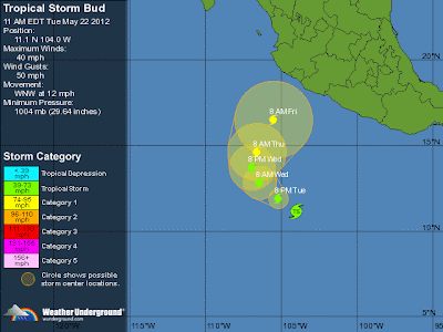
As seen in the image aside, bud has developed to a Cat 2, hurricane, for which 1 Minute Maximum Sustained Winds is between 154-177. It is dangerous but the center is far (Cat 2 impact within circle). As it moves further, its seems to be weakening and finally changing its route too.
Update 2012/05/24
-As of 800 PM PDT (0300 UTC), tropical storm bud is located 655 km SW of Manzanillo Mexico.
-The government of Mexico has issued a tropical storm watch along the Pacific coast from Punta San Telmo to la Fortuna.
-The center of Bud is forecast to approach the southwestern coast of Mexico by late Friday.
OVER WARM WATERS AND IN A LIGHT-SHEAR AND RELATIVELY MOIST
ENVIRONMENT...BUD SHOULD REACH HURRICANE STRENGTH SHORTLY. BEYOND
24 HOURS...PROGRESSIVELY COOLER WATERS...A DRIER AND MORE STABLE
ENVIRONMENT...AND SOME MARGINAL INCREASE IN SOUTHERLY SHEAR WILL
LIKELY INDUCE WEAKENING. THE PROXIMITY OF THE TRACK TO SOUTHWESTERN
MEXICO IN 48-72 HOURS SUGGESTS THE POTENTIAL FOR LAND INTERACTION
AND AN EVEN FASTER WEAKENING THAN PREDICTED. EITHER THE LESS
FAVORABLE ENVIRONMENT OR INTERACTION WITH THE MEXICAN COAST SHOULD
CONTRIBUTE TO WEAKENING TO REMNANT LOW STATUS LATER IN THE FORECAST
PERIOD. THE OFFICIAL NHC INTENSITY IS SIMILAR TO BUT SLIGHTLY HIGHER
THAN THE PREVIOUS ONE AND CLOSEST TO THE FSSE MODEL OUTPUT
Update 17:27 UTC
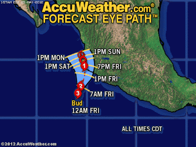
Forecast for May 24
-The image above is the tracking route for Bud for May 24 (early morning and mid day). As earlier Bud was expected to enter Mexico from manzanillo, now from this image it shows diversion in its path. But it is just a expected tracking route for tomorrow. If the recent route is considered for explanation, storm will have certain impacts in Mexico in next 69 hours only. It means by May 26.
-For May 25, there is 50% chance of precipitation in Manzanillo, Mexico.
-Today it is forecast to be Warmer than yesterday.
Update 2012/05/23
At 800 am PDT (1500 UTC), the center of Tropical Storm Bud was located near latitude 13.4 north longitude 107.6 west. Bud is moving toward the northwest near 9 mph (15 km/h). A turn toward the north with a decrease in forward speed is expected tonight and early Thursday followed by a turn toward the north-northeast by early Friday.
Update 18:03 UTC; 2012/05/22
-By 24 afternoon (UTC), Bud is expected to strengthen to a category Cat 1 (Hurricane).
-It has already developed to a tropical storm (a level below Hurricane).
-It will enter Mexico from Manzanillo. Effects will be seen in Tomatlan, Playa azu, Tepic and Gudalajara.
-The Eastern Pacific hurricane season begins May 15th and also ends November 30th.
Update
As of late Tuesday morning, the U.S. National Hurricane Center in Miami said Bud was centered about 485 miles (781 kilometers) south of Zihuatanejo, Mexico, and was moving west-northwest near 13 mph (21 kph). No coastal warnings or watches have been issued.
Tropical storm Two-E
-Currently Two-E is just a tropical depression but t is expected to become a tropical storm late today (Tuesday) and a a hurricane on Wednesday.
-Tropical Storm Bud is maintaining maximum sustained winds near 40 mph (65 kph).
-It is located 815 km SSW of Acapulco Mexico.
-On May 22 2011, deadly Joplin Missouri tornado (EF-5 tornado) killed 161 people.
This February Tropical Storm Irina Claimed 73 Lives. Cyclone Giovanna also did a lot of destruction in Mauritius and Madagascar.
Can anyone say, where is the hurricane in Mexico? I am told to be in alert condition by hotel manager??
ReplyDeleteAl, the trips, swimming schedule is changed :((
is that there is tsunami warning for nesika beach?? any news
ReplyDeletethanks for the great updates on this hurricane. I will be regularly following this blog for more updates.
ReplyDeleteIt is raining in vallarta...
ReplyDelete